
Case Study #2: Water Well and Groundwater Studies
Using ERI and SP geophysical methods as a means to determine ground water deposits and flow allowing for more accurate searches for water for well placement.
Geophysical methods provide an efficient and non-invasive way to identify optimal locations for groundwater production wells and environmental monitoring wells. Techniques such as electrical resistivity, seismic refraction, EM surveys, and passive seismic mapping help delineate aquifer boundaries, identify high-permeability zones, estimate depth to bedrock, and detect fractures or preferential flow paths. By integrating geophysical data with hydrogeologic modeling and borehole information, project teams can place wells more accurately, reduce drilling risks, and improve well performance and long-term monitoring reliability.
For this project, a combination of self-potential and electrical resistivity imaging was utilized to site groundwater wells in a complex fractured-rock environment. Electrical resistivity imaging is utilized to map or identify fractures and rock discontinuities in the study areas. Self-potential studies are then conducted over identified fracture zones to determine which intervals produce preferential or higher-yield groundwater flow. This process can reduce drilling costs in karst and fractured rock environments.
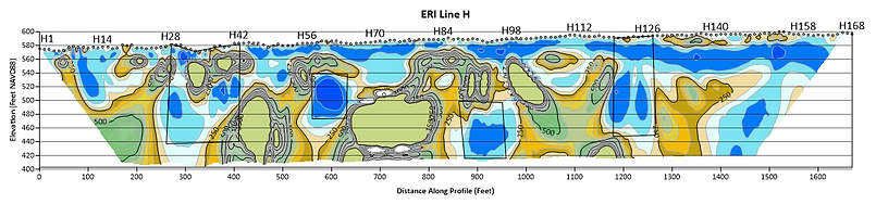
Photo 1 (below): In this photo we have processed the ERI data obtained at one of the sites we characterized, in this data there are several notable anomalies marked by rectangular boxes. Moving from left to right they can be described as Anomaly 1, a break in lithological layering allowing potential groundwater to come to the surface. Anomaly 2, a pocket of potential groundwater with notably less resistivity than surrounding layers. Anomaly 3, same as anomaly 2 in reference to resistivity. Anomaly 4 is potential groundwater being pushed to the surface due to shifting of lithological layering.

Picture 2: In the photo below we overlaid Self-Potential (SP) and Electrical Resistivity Imaging (ERI) to show where two anomalies overlapped, in order to pinpoint a prime drilling location in the search for groundwater
